St. Louis River Area of Concern
About
About the St. Louis River River AOC
Largest tributary to Lake Superior
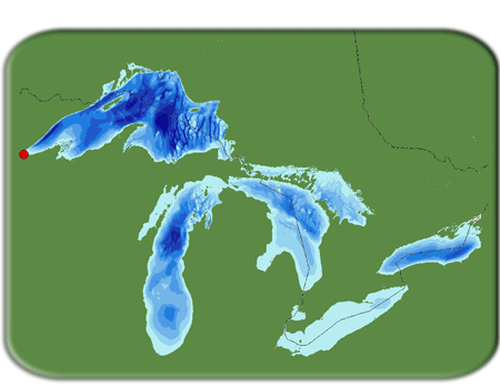
The largest U.S. tributary to Lake Superior, the St. Louis River drains 3,634 square miles, entering the southwestern corner of the lake between Duluth, Minnesota, and Superior, Wisconsin. The river flows 179 miles through three distinct areas:
- coarse soils, glacial till and outwash deposits at its headwaters;
- a deep, narrow gorge at Jay Cooke State Park; and
- red clay deposits in its lower reaches.
As it approaches Duluth and Superior, the river takes on the characteristics of a 12,000-acre freshwater estuary.
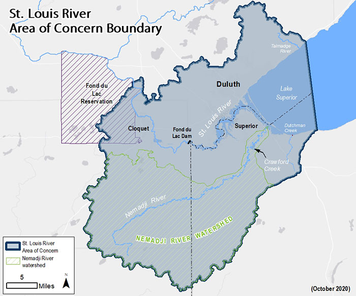
The AOC boundary includes the lower 39 miles of the St. Louis River, from upstream of Cloquet, Minnesota, to its mouth at the Duluth/Superior Harbor, and that portion of the watershed; the Nemadji River watershed; and the western portion of Lake Superior approximately 10 miles from the mouth of the river (see map).
The upper estuary has some wilderness–like areas, while the lower estuary is characterized by urban development, an industrial harbor and a major port. The lower estuary culminates in the Duluth–Superior Harbor, which is one of the more heavily used ports on the Great Lakes. In 1987, concerns over environmental quality conditions prompted the designation of the lower 39 miles of St. Louis River as one of 43 Great Lakes Areas of Concern.
Historical actions such as improper municipal and industrial waste disposal and unchecked land use practices, including dredging and filling of aquatic habitat and damaging logging practices, contributed to the complex set of issues facing the AOC at the time it was listed.
Major funding for many of the projects in the St. Louis River AOC comes from the Great Lakes Restoration Initiative administered by the U.S. EPA.
Community Engagement
Community Advisory Committee (CAC)
Created in 1996 as a nonprofit, the St. Louis River Citizens Action Committee's (SLRCAC) primary focus and efforts was to foster communication between public and tribal agencies, industry groups and community stakeholders in the implementation of the RAP. The CAC also advocates and sponsors stewardship efforts as well as promotes sound management of the resources provided by the St. Louis River, Lake Superior and their watersheds.
In 2009, the SLRCAC began doing business as the St. Louis River Alliance. Alliance members include individuals, families, businesses, organizations, local and tribal governments – all helping to support our work to improve the St. Louis River.
St. Louis River Alliance
394 South Lake Avenue, Suite 321
Duluth MN 55802
Office Phone: 218–733–9520
Office Fax: 218–723–4794
Email: slrcac@stlouisriver.org
St. Louis River Alliance website
St. Louis River Estuary: The Stories and the Science
Visit The Stories and the Science website to explore the stories of the estuary through the eyes of people that live and work here and delve into the science of the interplay between humans and ecosystems. Challenge yourself with real-world Geoquests or see how deep maps capture the beauty and complexity of this special place.
Get Involved
To learn more about AOC community events, volunteer opportunities and more, check out these links.
Maps
Maps
Impairments
Impairments
The majority of the beneficial use impairments (BUIs) listed for the St. Louis River AOC are due to historic habitat loss from the extensive filling of wetlands and dredging of shallow aquatic habitat, and releases of waste materials that contaminated the sediments and water in the estuary. Some sediment–derived contaminants also appear to be carried by the water column to Lake Superior, the most pristine Great Lake. The States are responsible for implementing Remedial Action Plans to remove the impairments and delist the St. Louis River as an Area of Concern.
Of the 14 beneficial uses, nine are listed as impaired for the St. Louis River.
- Restrictions on fish and wildlife consumption
- Degradation of fish and wildlife populations - BUI removed January 2023
- Fish tumors or other deformities - BUI removed February 2019
- Degradation of benthos
- Restrictions on dredging activities
- Excessive loading of nutrients and sediments - BUI removed April 2020
- Beach closings and body contact
- Degradation of aesthetics - BUI removed August 2014
- Loss of fish and wildlife habitat
Timeline for removing impairments
Final BUI removal packages with cover letters
AOC Plans
AOC plans
The St. Louis River Area of Concern continues to make progress toward delisting each year. The Remedial Action Plan is an annual document that provides an update on the AOC work and outlines the strategy for completing the remaining actions.
- 2024 Remedial Action Plan
- 2023 Remedial Action Plan
- 2022 Remedial Action Plan
- 2021 Remedial Action Plan
- 2020 Remedial Action Plan
- 2019 Remedial Action Plan
- 2018 Remedial Action Plan
- 2017 Remedial Action Plan
- 2016 Remedial Action Plan
- 2015 Remedial Action Plan
- 2014 Remedial Action Plan
- 2013 Roadmap Summary brochure
- 2013 Remedial Action Plan Update: Roadmap to Delisting - This plan outlines the actions required to remove all Beneficial Use Impairments.
- 2012 Remedial Action Plan
- 2011 Stage 2 Remedial Action Plan Update
- 2011 St. Louis River Area of Concern Complete Delisting Targets
- 2008 St. Louis River Area of Concern Delisting Targets
- 2002 Lower St. Louis River Habitat Plan
- 1998 Nemadji River Basin Project Report
- 1995 St. Louis River System Remedial Action Plan Progress Report
- 1992 St. Louis River Remedial Action Plan
Resources
Resources
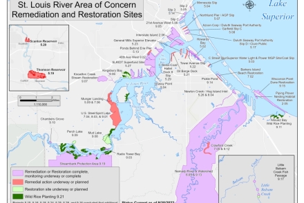
- Contaminated Sediment Remediation Sites
- Wisconsin Habitat Restoration Sites
- Beneficial Use Impairment (BUI) Restoration Report - Winter 2023
- St. Louis River AOC 2023 display
- Fish consumption advice for St. Louis River
Feature Videos
The following videos highlight the basic principles of Areas of Concern while highlighting some projects in the St. Louis River Estuary.
Little Balsam Creek Fish Passage Project
This project replaced culverts under roads crossing Little Balsam Creek that prevented trout and other fish from swimming upstream. The new culverts are better sized to handle higher flood waters and allow fish to swim through at any water level, even very low flows. Fish now have a clear path for over five miles from Lake Superior throughout the upper reaches of Little Balsam Creek.
Restoring Wild Rice in the St. Louis River Estuary
Wild rice, or manoomin in Ojibwe, is a nutritional grain that is central to the cultural identity of the Ojibwe people. It's also an important ecological resource that's largely been lost in the St. Louis River estuary. This video shows how we are working with the Fond du Lac Band of Lake Superior Chippewa, the Great Lakes Indian Fish & Wildlife Commission and other partners to restore 275 self-sustaining acres in the AOC.
Protecting Dunes and Restoring and Piping Plover Habitat on Wisconsin Point
One project at this unique and important place protected sensitive dune habitats and historical sites, while also improving public beach access for people who are mobility challenged. Another project created 14 acres of new habitat for the endangered Piping Plover at the DNR-owned Wisconsin Point Bird Sanctuary.
Restoring Barker's Island Beach in Superior
The beach at Barker's Island in the city of Superior now has cleaner water thanks to added native plants and improved access for people to enjoy the water through ecologically sound parking and beach upgrades. This project is part of the larger effort to restore the St. Louis River AOC.
Additional Videos
The following videos are from the Minnesota DNR.
- Sturgeon Habitat Restoration project on the St. Louis River AOC [Video Length: 3:33]
- Sturgeon Tagging on the St. Louis River [Video Length: 2:49]
Projects
Projects
Wisconsin leads approximately 25 management actions in the St. Louis River AOC. Of the 80 total actions, 53 have been completed. These actions include habitat restoration, sediment cleanup and monitoring and assessment projects.
Wisconsin Project Fact Sheets
- Barkers Island Inner Beach
- Howards Bay Sediment Remediation
- Interstate Island Avian Habitat Restoration
- Little Balsam Creek Fish Passage Project
- Pickle Pond Restoration
- Piping Plover Habitat Restoration
- Wild Rice Restoration
- Wisconsin Point Dune Restoration
Plans
Reports
Coordination With Minnesota
Minnesota leads approximately 31 actions in the St. Louis River AOC. To learn more see:
Completed Cleanup Sites
Contacts
Contacts
Matt Steiger
St. Louis River AOC Coordinator
Wisconsin Dept. of Natural Resources
Superior WI
715–395–6904
Melissa Sjolund
St. Louis River AOC Coordinator
Minnesota Dept. of Natural Resources
Duluth MN
218-302-3245
Barb Huberty
St. Louis River AOC Coordinator
Minnesota Pollution Control Agency
Duluth MN
218-302-6630
Rick Gitar
Water Regulatory Specialist
Fond du Lac Resource Management – Fond du Lac Band of Lake Superior Chippewa in Minnesota
Cloquet Minnesota
218–878–7122


