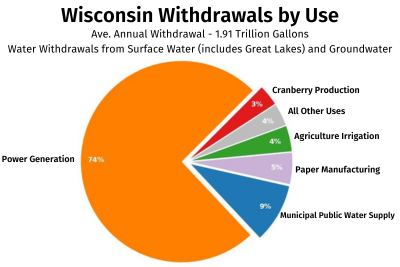
Wisconsin water withdrawals
Every year, all registered high capacity property owners are required to submit monthly water use (withdrawal) totals to the DNR. Statewide, there are over 14,000 registered high capacity withdrawal sources including over 13,000 groundwater and 1,000 surface water sources.
A Decade of Wisconsin Water Withdrawals is a DNR StoryMap that provides visitors an interactive summary of water withdrawals across Wisconsin. Current and past water withdrawal data can also be explored through the water quantity data viewer and the water withdrawal search tool.
Each year, over 95% of property owners report on their water withdrawals. The majority of these reports are submitted online. Owners measure water withdrawals with meters or estimate their withdrawals with a DNR-approved method.
Reports and data
Withdrawal sources
The sources for Wisconsin withdrawals vary depending on the where the withdrawal takes place. A large majority of the water withdrawn is taken directly from Lake Michigan to supply cooling water for electric power generation and for municipal water supplies. In the Mississippi River Basin, groundwater is more commonly used for municipal public water supplies and agricultural irrigation. There are relatively few withdrawals made in Wisconsin's portion of the Lake Superior Basin.
On average, Wisconsin residents and businesses withdraw about 1.9 trillion gallons of water annually. This volume is roughly:
- enough water to cover the state of Wisconsin in 1.6 inches of water;
- about as much water as passes by La Crosse in the Mississippi River in 3.5 months; and
- over 300,000 gallons per Wisconsin resident, per year. That’s equivalent to about 1.3 million large fountain drinks per person, per year.
Sharing data
To meet Great Lakes-St. Lawrence River Basin Resources Great Lakes Compact and state law requirements, the DNR maintains a database on water withdrawals and reports annual water use to the Great Lakes Commission [exit DNR].
Wisconsin creates summaries of annual withdrawals for the public. Locations and volumes of past reported withdrawals can be viewed using the Water Quantity Data Viewer.
Water use reports and summaries
- 2023 Water Use StoryMap
- 2023 Water Use Report
- 2022 Water Use Report
- 2021 Water Use Report
- 2017 Water Use Report [PDF]
- 2016 Water Use Report [PDF] — Lake Michigan Surface Water Use Summary
- 2015 Water Use Report [PDF]
- 2014 Water Use Report [PDF]
- 2013 Water Use Report [PDF] and Summary [PDF]
- 2012 Water Use Report [PDF] and Summary [PDF]
- 2011 Water Use Report [PDF] and Summary [PDF]

