Air Dispersion Modeling
Air dispersion modeling simulates how air pollutants disperse in the atmosphere. Inputs to the model include emissions, stack parameters, meteorological data, terrain and the height of surrounding structures. Dispersion modeling is performed with computer programs that solve complex mathematical equations to calculate the downwind concentration of air pollutants from industrial sources. Air dispersion modeling is used by the DNR as part of the permit process to ensure that emissions from sources do not violate applicable air quality standards. Modeling also has applications in rule development and compliance determinations.
Air Quality Standards
Air Quality Standards
Wisconsin has air quality standards that address criteria and non criteria pollutants. Criteria pollutants are those air pollutants where National Ambient Air Quality Standards (NAAQS) [exit DNR] have been established by the U.S. Environmental Protection Agency (EPA). These NAAQS are contained in s. NR 404.04, Wis. Adm. Code [exit DNR].
There may be differences between EPA's official list of NAAQS and those listed in s. NR 404.04, Wis. Adm. Code. When new or revised air quality standards are issued by EPA, the DNR is required by statute to incorporate updated air quality standards and this process can often take several months.
Chapter NR 445, Wis. Adm. Code [exit DNR], sets acceptable ambient concentrations for non criteria pollutants. Each of the pollutants listed in Tables A-C of NR 445.07, Wis. Adm. Code, lists an acceptable ambient concentration that varies depending on the height of the stack in which the pollutant is emitted and the modeling time period for that pollutant.
- A spreadsheet [XLS] listing the acceptable ambient concentration for each pollutant.
Policy and Guidance
Dispersion Modeling Policy
Modeling Technical Support
Meteorological Data
Meteorological Data
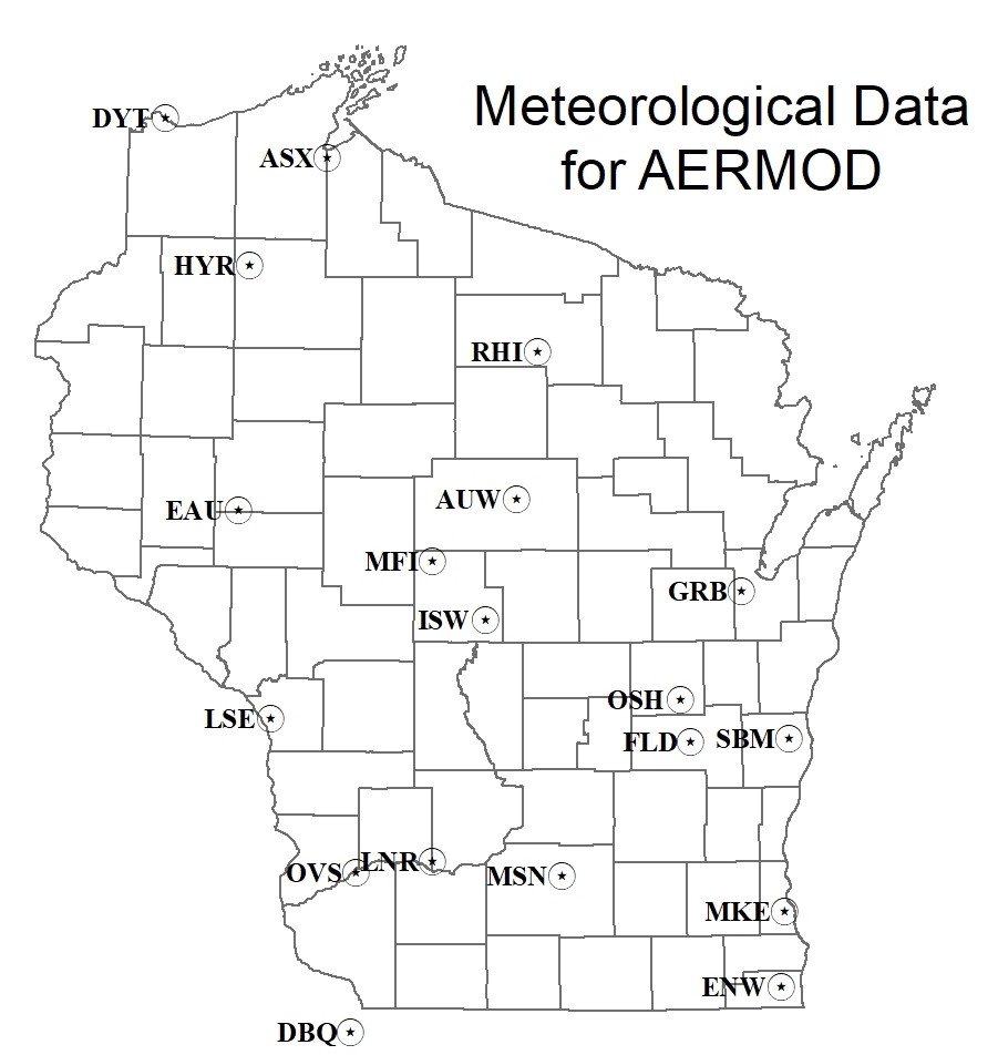
The DNR has extracted, quality assured and merged raw surface and upper air data from a number of stations for use in AERMOD (the EPA-recommended dispersion model). Land use information allowed for processing surface characteristics within one kilometer of the instrumentation site to provide complete surface and profile files.
- DNR memorandum that contains specific details on the AERMET processing [PDF]
- Data table with site-specific meteorological data [PDF]
Map showing monitoring locations in Wisconsin
Links
Important modeling links
- EPA Technology Transfer Network - Support Center for Regulatory Atmospheric Modeling (SCRAM) [exit DNR]
U.S. EPA Policy Memos
- Guidance for Ozone and Fine Particulate Matter Permit Modeling
- Guidance on the Development of Modeled Emission Rates for Precursors (MERPs)
- Significant Impact Levels for Ozone and Fine Particles
- January 2017 U.S. EPA Guideline on Air Quality Models (Appendix W)
- Clarification on the Use of AERMOD Dispersion Modeling for Demonstrating Compliance with the NO2 National Ambient Air Quality Standard
- Additional Clarification Regarding Application of Appendix W Modeling Guidance for the 1-hour NO2 National Ambient Air Quality Standard
- Applicability of Appendix W Modeling Guidance for the 1-hour SO2 National Ambient Air Quality Standard
- Applicability of Appendix W Modeling Guidance for the 1-hour NO2 National Ambient Air Quality Standard

