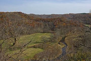
Eagle Eye
No. 675

Photo by Thomas A. Meyer/DNR
The site gets its name from a narrow, horizontal slit in a bedrock outcrop at the summit of a curving ridge, 250' above the floodplain of the North Fork of the Bad Axe River. The ridge is forested with restorable oak woodland and oak savanna, and small pockets of dry prairie are still present on the ridge's spine. Prescribed fire and brushing to remove woody understory species are expanding the prairie areas and improving the quality and diversity of the woodland/savanna complex. Low cliffs and rock shelters add diversity to the site and provide a habitat for cliff-dwelling plant species.
State-threatened cerulean warblers and state-threatened cherrystone drop snails (one of the largest populations in the state) are found in the forest. At the base of the ridge a stretch of the North Fork of the Bad Axe River meanders through degraded wetlands and former agricultural fields slated for restoration. The river is a Class II trout stream, holding a diverse fishery that includes brown and rainbow trout, northern pike, smallmouth and largemouth bass, panfish, burbot, yellow perch and a variety of minnows and other forage fish.
Although the ecological values of the site are noteworthy, the natural area is known primarily for its cultural significance. Eagle Eye lies within the Cade Archeological District, a site on the National Register of Historic Places. Seven Native American effigy mounds are found on the south-facing flank of the ridge. They include a bear, panther, turtle, and two bird effigy mounds and two linear mounds. An adjacent, elevated terrace above the river floodplain shows evidence of historic agriculture. The mounds and garden plots date to ca. 1050 AD. Eagle Eye is owned by The Archaeology Conservancy with a management agreement with Mississippi Valley Conservancy. It was designated a State Natural Area in 2016.
Very few State Natural Areas have public facilities, but nearly all are open for a variety of recreational activities as indicated below. Generally, there are no picnic areas, restrooms, or other developments. Parking lots or designated parking areas are noted on individual SNA pages and maps. If a developed trail is present, it will normally be noted on the SNA map and/or under the Maps tab. A compass and topographic map or a GPS unit are useful tools for exploring larger, isolated SNAs.
The good majority of SNAs are isolated and have few or no facilities. Some SNAs have vehicle access lanes or parking lots, but their accessibility may vary depending on weather conditions. Parking lots and lanes are not plowed during winter. Hiking trails may be nonexistent or consist of undeveloped footpaths. A GPS unit or compass and a detailed topographic map are useful tools for exploring larger SNAs.
Non-DNR lands
Entrance fees: For non-DNR-owned SNAs, we are unaware of any vehicle or admission fees. However, please contact the landowner for more information.
Hunting and trapping
Other activities
Other allowable activities such as - but not limited to camping, geocaching and bicycling are determined by the landowner. Please contact them directly or visit their websites for details.
Location
Vernon County. T13N-R6W, Section 24. 70 acres.
Driving directions
From the intersection of Highways 14 and 56 in Viroqua, go west on 56 for 7.7 miles, then go north on County Highway O for 3.6 miles, then go east on Upper Newton Road for 1.5 miles. The property lies north of the road and just past driveway E4337. It's marked by a Mississippi Valley Conservancy property sign. To access the ridge, one must ford the North Fork of the Bad Axe River. There are rocky riffles where the water is shallow enough during normal flows to allow crossing in less than knee-high water.
The DNR's state natural areas program comprises lands owned by the state, private conservation organizations, municipalities, other governmental agencies, educational institutions and private individuals. While the majority of SNAs are open to the public, access may vary according to individual ownership policies. Public use restrictions may apply due to public safety, or to protect endangered or threatened species or unique natural features. Lands may be temporarily closed due to specific management activities.
Users are encouraged to contact the landowner for more specific details. The data shown on these maps have been obtained from various sources, and are of varying age, reliability, and resolution. The data may contain errors or omissions and should not be interpreted as a legal representation of legal ownership boundaries. To create your custom map where you can zoom to a specific location, please use the DNR's Mapping Application.
Eagle Eye is owned by The Archaeological Conservancy (TAC) with a management agreement with Mississippi Valley Conservancy.
