Recreation Opportunities Analysis
The Wisconsin Department of Natural Resources' mission includes providing a healthy, sustainable environment in which a full range of outdoor opportunities may be enjoyed by all people. To better understand existing outdoor-based recreation opportunities and future recreation needs in each region of the state, the department conducted the study known as the Recreation Opportunities Analysis (ROA). The study involved collecting and analyzing information from the public, local governments, recreation groups, and department property managers. The ROA identifies future needs to provide high-quality recreation experiences and the role that department properties can help to meet those needs. The ROA is intended to be a resource during department property planning processes.

- Goals
-
The goals of the Recreation Opportunities Analysis are to:
- ensure that DNR resources are focused on providing recreational opportunities in the most appropriate places;
- identify the highest priority future recreational needs in each planning region and the department properties that are best suited to meet these priorities;
- provide information on the full spectrum of outdoor recreation in each region to the department's master planning process, and further, provide information and guidance that enables the master planning process to identify which roads on DNR properties should be open to motorized vehicles;
- use the best available information to identify existing recreation opportunities and future needs and priorities in each region of the state; and
- ensure there is ample opportunity for public and stakeholder input in selecting priorities.
- Products
-
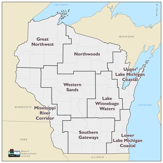
Our study of recreation opportunities in Wisconsin is divided into eight regional chapters. These chapters describe existing recreation opportunities, future needs and priorities, and the potential role of state-owned lands in helping meet these priorities. The chapters also provide guidance to the department’s master planning process on a wide variety of recreation needs, including opportunities for incorporating new recreation uses and motorized access.
- Process
-
The department started by engaging representatives of statewide stakeholder groups from a variety of recreation interests. This group helped the department develop a set of recreation goals and objectives and develop criteria to identify appropriate locations for recreational activities. The criteria include attributes and conditions needed to provide a high-quality recreational experience, identify the potential impacts of those activities and determine the appropriate geographic distribution of opportunities.
Next, the department engaged with the public, recreation providers, business and environmental groups and department property managers. For purposes of this study, the department used eight regions [PDF] developed by previous recreation studies. The department completed draft chapters reflecting the information gathered from the public, recreation user groups, and department staff. These chapters were made available for public review. After making edits, the chapters were finalized by the department.
- Connection to other projects
-
This analysis is being conducted concurrently with a legislatively-mandated DNR project to inventory and map all roads on department properties. The results of this road inventory project will help inform the Recreation Opportunities Analysis.
Also concurrent with this analysis is the development of the 2017-2022 Statewide Comprehensive Outdoor Recreation Plan (SCORP).
The department will be using the results of the Recreation Opportunities Analysis to help inform the development of department master plans across the state.
- Northwoods Region
-
The following maps have been prepared to provide background information. They are based on the best information that the department could gather at this time.
- Upper Lake Michigan Coastal Region
-
The following maps have been prepared to provide background information. They are based on the best information that the department could gather at this time.
- Great Northwest Region
-
The following maps have been prepared to provide background information. They are based on the best information that the department could gather at this time.
- Mississippi River Corridor Region
-
The following maps have been prepared to provide background information. They are based on the best information that the department could gather at this time.
- Western Sands Region
-
The following maps have been prepared to provide background information. They are based on the best information that the department could gather at this time.
- Lake Winnebago Waters Region
-
The following maps have been prepared to provide background information. They are based on the best information that the department could gather at this time.
- Lower Lake Michigan Coastal Region
-
The following maps have been prepared to provide background information. They are based on the best information that the department could gather at this time.
- Southern Gateways Region
