North Country National Scenic Trail

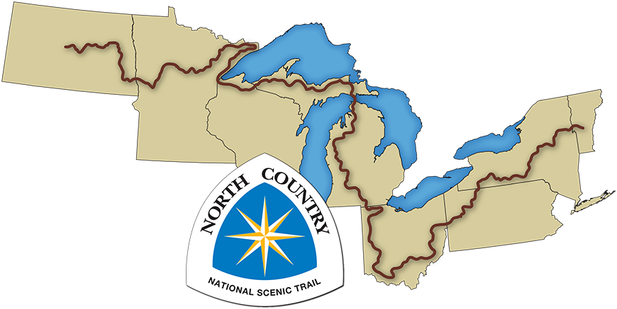
The North Country National Scenic Trail is a premier hiking and backpacking trail that travels for more than 4,600 miles through eight northern states from Lake Sakakawea State Park in North Dakota to the Appalachian Trail in Vermont. The North Country Trail is one of 11 National Scenic Trails in the United States and is also one of 44 designated Wisconsin state trails.
In Wisconsin, the North Country Trail clips the northwest corner of the state for 220 miles, passing through Douglas, Bayfield, Ashland and Iron counties. The North Country Trail route crosses Wisconsin’s western border just south of Minnesota’s Jay Cooke State Park and the trail crosses into Michigan’s Upper Peninsula via the State Highway 122 bridge across the Montreal River southeast of Saxon Harbor.
Although Wisconsin has the second shortest trail distance among the eight states the trail passes through, Wisconsin is responsible for providing the name to the North Country Trail. The original 60-mile Northern Country Trail in the Chequamegon-Nicolet National Forest lent its name to the 4,600-mile National Scenic Trail when the idea of the multi-state trail was first envisioned.
North Country Trail maps
More than 140 miles of the North Country trail are completed in Wisconsin. The completed sections of the trail are connected by roadways and other temporary routes in Douglas, Bayfield, Ashland and Iron counties for a total length of 220 miles. Distances between trailheads and access points can vary greatly and hikers may want to review a map before setting out.
The best source for detailed maps, local contact information and descriptions of the various trail segments are available from the North Country Trail Association exit DNR], where you can find an online interactive map of trail segments in Wisconsin and other states. Topographic hiking maps are available as free downloads for printing at home or for use with your smartphone.
The North Country Trail is also listed on the maps of the state parks and forests it travels through.
North Country Trail in state parks and forests
The North Country Trail goes through some state and federal lands in northwest Wisconsin. In addition to the parks and forests listed below (from west to east along the trail), the North Country Trail travels many miles through county and private lands.
- Pattison State Park
- Brule River State Forest
- Chequamegon-Nicolet National Forest [exit DNR]
- Copper Falls State Park
State North Country Trail Areas
State North Country Trail Areas (SNCTAs) are lands purchased by the DNR for the North Country National Scenic Trail under the authority of s. 23.09 (2)(d) 12., Stats., unless purchased as part of another department project. The primary purpose of State North Country Trail Areas is to permanently protect segments of the North Country Trail and the natural resources along it for present and future public use and enjoyment.
SNCTAs are open for hiking/walking. Some properties or portions of properties are open for hunting and trapping during the Wisconsin state parks hunting time frame. No hunting or trapping is allowed within 100 yards of the North Country National Scenic Trail on SNCTA properties. For more information, please see: Hunting and trapping in Wisconsin State Parks.
Recreation along the North Country Trail
The North Country Trail is primarily an off-road hiking and backpacking trail that provides excellent opportunities for sightseeing, wildlife viewing and bird watching. In winter some sections of the trail are open for cross-country skiing and snowshoeing. Motorized vehicles are not allowed on the North Country Trail.
Camping
Opportunities are available for camping along the North Country Trail in the Chequemegon-Nicolet National Forest, Brule River State Forest, county forests, Pattison and Copper Falls state parks and other public and private campgrounds. Campgrounds can vary from primitive walk-in campsites to facilities complete with electric hookups. When planning a trip, it is best to check ahead of time for camping locations and availability.
In the Chequamegon-Nicolet National Forest, there are developed campgrounds near the trail as well as three Adirondack shelters. Camping is also allowed along the trail in the National Forest but campsites must be kept 50 feet away from the trail or any water source such as lakes and streams.
North Country Trail partners
The Wisconsin Department of Natural Resources and its partners, the National Park Service and the North Country Trail Association, cooperatively develop and maintain the North Country Trail in Wisconsin. Additionally, the DNR works with many volunteers, county and local governments and private landowners to continually open new sections of the trail. An agreement [PDF] between the DNR, National Park Service and North Country Trail Association explains the roles of the partners.
National Park Service
The National Park Service (NPS) [exit DNR] began studying the concept of the North Country Trail in the late 1960s. In 1980 Congress and the president designated the trail as a National Scenic Trail. The NPS works with the North Country Trail Association and DNR on the construction, funding and protection of the trail and coordinates the planning process for the North Country Trail corridor. The DNR and NPS also work together on another National Scenic Trail in Wisconsin, the Ice Age Trail.
North Country Trail Association
The North Country Trail Association (NCTA) [exit DNR] is a nationwide, nonprofit, volunteer organization whose mission is to develop, maintain, preserve and promote the North Country Trail. There are local chapters in all eight states the trail passes through. The National Headquarters is in Lowell, Michigan. Volunteers with the Brule-St.Croix, Chequamegon and Heritage NCTA chapters play a key role in creating, supporting and protecting the various North Country Trail sections in Wisconsin.

