Wisconsin's Continuous Forest Inventory (WisCFI)
The Wisconsin Continuous Forest Inventory (WisCFI) collects and reports on the condition of Wisconsin's state forests in a statistically sound manner. The data is collected from a system of permanent plots to track forest conditions on an annual basis.
WisCFI provides unbiased and reliable information at the property level with the ability to compare to regional or statewide trends, such as Forest Inventory and Analysis [exit DNR]. The data can also assist in state forest planning, management and monitoring. The information collected in WisCFI can be used to track the status and trends in forest extent, cover, volume, growth, mortality, removals, habitat and overall health.
Methods
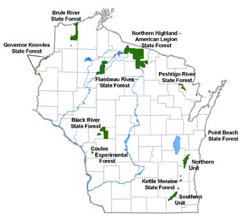
The inventory covers 10 properties designated as state forests. These forests are generally located in the northern half of the state and total 526,947* acres:
- Black River State Forest - 68,706 acres
- Brule River State Forest - 46,667 acres
- Coulee Experimental Forest - 2,944 acres
- Flambeau River State Forest - 89,975 acres
- Governor Knowles State Forest - 20,614 acres
- Northern Highland-American Legion State Forest - 234,366 acres
- Kettle Moraine State Forest (northern unit) - 30,041 acres
- Kettle Moraine State Forest (southern unit) - 21,315 acres
- Peshtigo River State Forest - 9,403 acres
- Point Beach State Forest - 2,917 acres
* Acres based on 2011 property acres used for determining plot selection.
Data collection
WisCFI uses a plot system for collecting data. The plots are placed at a density of approximately one plot per 200 acres of state forest land. Each year one-fifth of the plots--called a panel--are sampled for data collection.
WisCFI's data collection process began in 2007 and 2011 marked the end of the first complete cycle of data collection for all five panels. In 2012, the same plots from the first panel were resampled and each successive year the next panel will be resampled. By re-sampling the plots, data is collected on tree growth, mortality and removals, among other things.
Field manuals
- Field Manual Volume I: P2 Plots
- Field Manual Volume II: P3 Plots
Statewide Reports
- Continuous Forest Inventory – Baseline Report 2007 – 2011 [PDF]
- Continuous Forest Inventory – Annual Report 2015 [PDF]
2012 state forest reports
- Black River State Forest [PDF]
- Brule River State Forest [PDF]
- Coulee Experimental State Forest [PDF]
- Flambeau River State Forest [PDF]
- Governor Knowles State Forest [PDF]
- Kettle Moraine State Forest - Northern Unit [PDF]
- Kettle Moraine State Forest - Southern Unit [PDF]
- Northern Highland American Legion State Forest [PDF]
- Peshtigo River State Forest [PDF]
WisCFI Data Tables
Data Availability
Wisconsin CFI data is available for public consumption and use. The most recent data can be accessed by the Forest Inventory Analyst.
WisCFI plot location and access policy
To protect the integrity of the plots, their exact locations are kept confidential. Approximate locations of WisCFI plots are available to the public.
Requests for exact plot locations are subject to review and approval by the department's WisCFI Plot Access Committee. All requests for exact plot locations must be submitted in writing and are dependent on department approval (see plot locations policy [PDF] for details).
Access to exact plot locations would only be granted under terms of a formal written agreement, which begins by submitting a Plot Location Request form [PDF]. Download and print the form, or contact Ryan Heiderman, forest inventory analyst. If after review the request is granted, both parties must enter into a formal memorandum of understanding.
Forest Inventory and Analysis (FIA) National Program - U.S. Forest Service
The Forest Inventory and Analysis Program [exit DNR] of the U.S. Forest Service provides the information needed to assess America's forests on a national level. This website provides FIA reports, data and tools, library, links and other important national program information including the Forest Inventory Data Online (FIDO), EVALIDator and FIA DataMart.

