Powell Marsh Wildlife Area
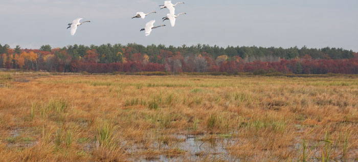
Powell Marsh State Wildlife Area spans approximately 4,303 acres in Vilas County. Find it 3 miles south of Manitowish Waters and 10 miles north of Lac du Flambeau. The wildlife area is on Powell Road between Highway 51 and Highway 47. The large peatland complex of Powell Marsh contains several unique wetland and plant communities and is a favorite area for birders, trappers and waterfowl hunters.
Some of the unique features of the marsh include:
- Open water flowages with submerged and floating aquatic plants.
- Unforested wetlands comprised of sedge meadows, alder and willow fens, and bogs with low shrubs, sphagnum moss and stunted spruce and tamarack.
- Forested wetlands of black spruce and tamarack.
- Grassy upland islands.
- Upland forests of aspen, white birch, red maple, red oak and white pine.
Management Objectives
Large, open peatland habitat is rare in northern Wisconsin, making Powell Marsh a regionally important wetland because of its large size and open character. The wetland system at Powell Marsh was maintained by wildfires for thousands of years. The last of the wildfires were in the 1930s and 1940s. These fires stimulated new vegetation growth that attracted large flocks of migrating geese. Sportsmen recognized the potential to attract geese to the area and petitioned the Wisconsin Conservation Commission to establish a goose management project. In 1955, the Powell Marsh State Wildlife Area was established to produce more geese for hunters.
Early management at Powell was one of the pioneering efforts to manipulate extensive northern sedge leatherleaf bog for geese. Managers used prescribed fire to stimulate new growth for fall waterfowl migrations. A system of ditches and dikes was constructed to provide water level control, enable prescribed burning and allow limited farming.
Today, Powell Marsh Wildlife Area provides wildlife-based recreation, particularly waterfowl hunting, trapping and birding opportunities. Management emphasizes habitat for waterfowl and species that require open wetland and grassland habitat. A combination of water-level controls, prescribed fire, hand cutting, mowing and shearing is used to limit the growth of shrubs and tamarack while increasing the abundance of grasses and sedges.
For more information on master planning for this and other wildlife areas around the state, visit the property planning page.
Recreation
Powell Marsh Wildlife Area provides ample opportunities for hunters, trappers, berry pickers, bird watchers and photographers. The most common hunting activity is for waterfowl, while deer hunters primarily use the upland edges of the marsh. The property is ideal for bird watching and viewing non-game species. To date, over 213 different bird species have been spotted at Powell.
A scenic overlook is located at the north end of the marsh and there are four designated parking areas across the property. There are no designated trails in the wildlife area, but roads and dikes provide walking access throughout much of the wildlife area. A designated hike and ski trail is adjacent to the western boundary of the marsh on the Northern Highland-American Legion State Forest.
Naturalists from the Northern Highland-American Legion State Forest and private naturalists offer guided interpretive programs at Powell Marsh. The most common programs include birding and wildflower hikes.
The Powell Marsh Wildlife Area offers many recreational opportunities:
- Birding
- Cross-country skiing (no designated trail)
- Fishing (limited potential)
- Hiking
- Hunting (850-acre no-entry wildlife refuge, except for trapping, gun deer and muzzleloader deer hunting, from Sept. 1 to Dec. 31, with refuge area posted)
- Trapping
- Wild edibles/gathering
- Wildlife viewing
Amenities
- Bathroom - None.
- Parking lot - Yes, there are four parking lots throughout the property.
- Campground and size - None.
- Trails, Types and Lengths - No designated trails but there are mowed hunter-walking trails.
- Other amenities - An ADA-accessible hunting blind on the north end of the property adjacent to Powell Road.
Maps
View or download a printable map of this property.
See existing and planned recreation infrastructure.
If you are interested in exploring this property further, you can access an interactive map.
Find out more about how to adopt this wildlife area.


