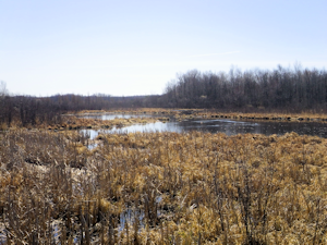
Bear Lake Fishery Area
DNR Fisheries Areas
The property was purchased in 1964 to protect Boyer Creek which serves as important fish spawning habitat for nearby Bear Lake while also providing a public fishing and hunting area. Known archaeological sites exist in the Bear Lake area.
A small section of the Ice Age trail crosses onto the fishery area near the Washburn/Barron County line. The trail is open to hiking, snowshoeing and cross-county skiing.
Location/Directions
The fishery area is located approximately 7.1 miles south and east of the city of Shell Lake. To get to the fishery area turn east off of U.S. Hwy 63 onto County Hwy D. Drive approximately 3.7 miles and turn south on Shallow Lake Road. Drive an additional 3.4 miles and arrive at a parking lot located on the east side of the highway.
Activities
Angling opportunities
Anglers can access Boyer creek by carry in access using canoe, kayak or by boat from nearby Bear Lake.
Recreational Opportunities
|
|
Objective
The Bear Creek fishery area is managed to protect fish spawning habitat on Boyer Creek, to manage upland habitat for wildlife and timber values and to provide access and recreation for angling, hunting, trapping, wildlife watching, hiking and other compatible outdoor recreational activities.
Contacts/Partners
For questions and comments contact:
Property Manager
Department of Natural Resources
810 W Maple Street
Spooner WI 54801
715-635-4022
Fisheries Biologist
Department of Natural Resources
810 W Maple Street
Spooner WI 54801
715-635-4095

