Milwaukee Estuary Area of Concern Projects
About
About the Milwaukee Estuary AOC Projects
This webpage includes information about 41 projects in the Milwaukee Estuary Area of Concern (AOC) that were selected to address the 11 beneficial use impairments (BUIs) for this AOC.
Project information is grouped according to the management action list under which the project will be completed:
- Contaminated sediment related BUIs
- Degradation of fish and wildlife populations BUI
- Loss of fish and wildlife habitat BUI
- Beach closings (recreational restrictions) BUI
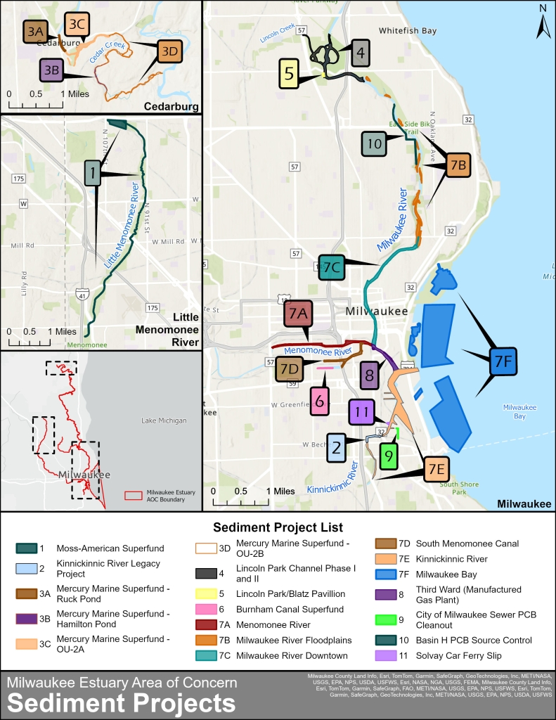
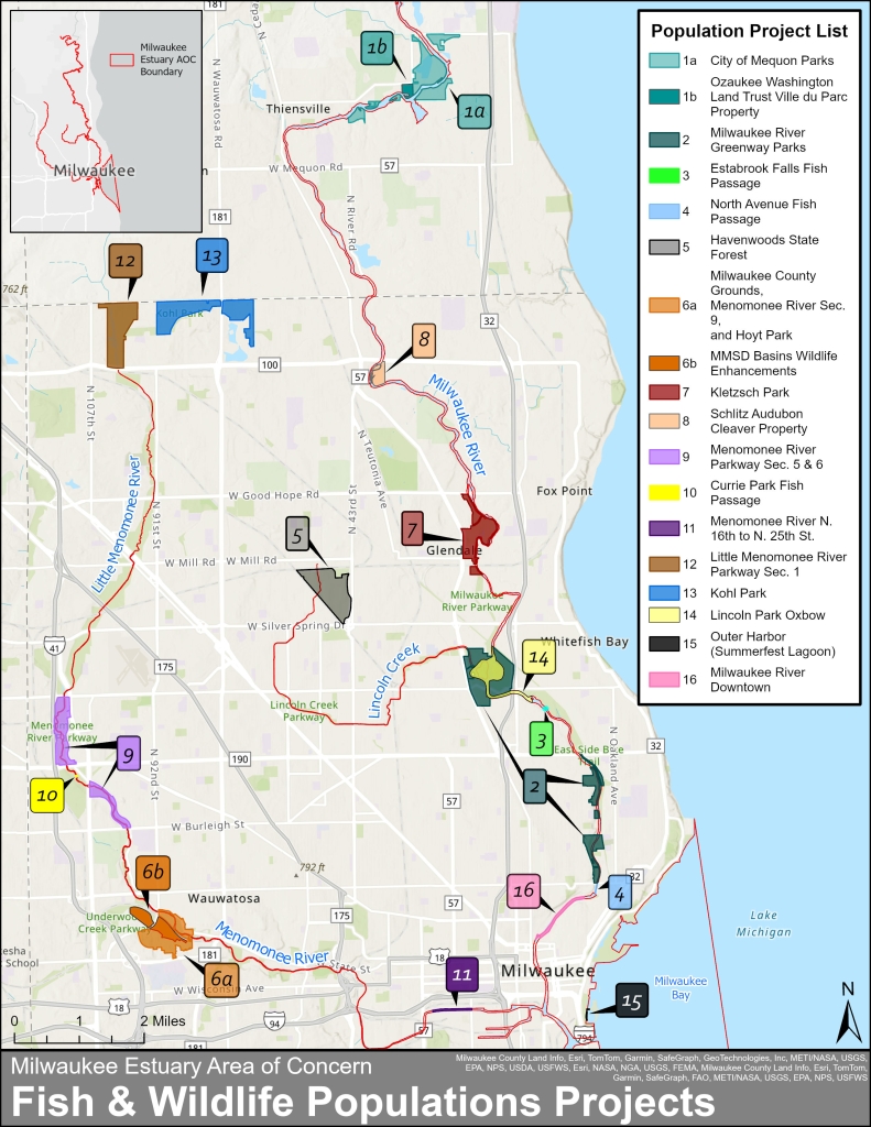
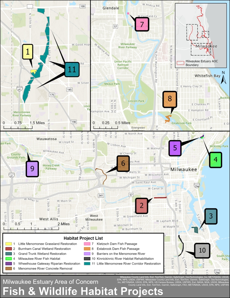
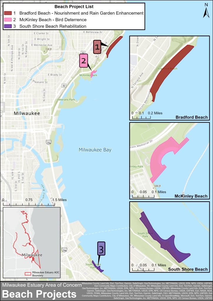
Each tab includes a list of the projects, a map of project locations, the general status, who is leading the projects and a link to more information (if applicable).
Contaminated Sediment
Contaminated Sediment Projects
There are 11 projects in the Milwaukee Estuary AOC that are designed to address five beneficial use impairments that are due to contaminated sediment. These projects address the following impairments:
- Restrictions on dredging activities
- Degradation of benthos
- Fish tumors or other deformities
- Bird or animal deformities or other reproductive problems
- Restrictions on fish and wildlife consumption
Some projects have multiple remediation steps. Projects typically involve dredging and disposing of the contaminated material to remove it from the waterways and in some cases, the adjacent floodplains. In situations where the contaminated material cannot be safely removed, it’s sealed in place so the toxins no longer move through the environment.
| Map Project Number | Contaminated Sediment Project Name | Lead Organization | Status | More Information |
| 1 | Moss-American Little Menomonee River Superfund Alternative Site | EPA | Complete | EPA website |
| 2 | Kinnickinnic River Sediment Removal Legacy Project | EPA | Complete | Great Lakes Mud website |
| 3 A-D | Mercury Marine Cedar Creek Superfund Alternative Site | EPA | Complete | EPA website |
| 4 & 5 | Lincoln Park and Blatz Pavilion Site | EPA | Complete | Great Lakes Mud website |
| 6 | Burnham Canal Superfund Alternative Site | EPA | Complete | EPA website |
| 7 A | Menomonee River Sediment Investigation | EPA | In progress | EPA report |
| 7 B | Milwaukee River Floodplains | EPA | In progress | WRP website |
| 7 C | Milwaukee River Downtown | EPA | In progress | WRP website |
| 7 D | South Menomonee Canal | EPA | In progress | |
| 7 E | Kinnickinnic River Mooring Basin Sediment Investigation | EPA | In progress | EPA report |
| 7 F | Milwaukee Bay | EPA | In progress | |
| 8 | Third Ward (Manufactured Gas Plant) | WE Energies | In progress | WRP website |
| 9 | City of Milwaukee Sewers PCB Cleanout | City of Milwaukee | In progress | |
| 10 | Basin H Sewers PCB Remediation Project | MMSD | In progress | MMSD website |
| 11 | Solvay Coke and Gas Company | WE Energies | In progress | EPA website |
EPA = U.S. Environmental Protection Agency
MMSD = Milwaukee Metropolitan Sewerage District
WRP = Waterway Restoration Partnership
Sediment Projects In Expanded AOC Boundaries
In 2008, the EPA approved expanding the geographic boundaries for the Milwaukee Estuary AOC because contributions of toxic substances from upstream sources had accumulated in the estuary since the original boundaries were drawn in the 1980s. The AOC boundaries were expanded north along the Milwaukee River into Cedarburg and west into Wauwatosa along the Menomonee and Little Menomonee Rivers to include specific project sites that contributed contaminated sediment into the waterways.
| Map Project Number | Description of Expanded AOC Sections | Projects | Status |
| 1 | Little Menomonee River from Brown Deer Road to confluence with Menomonee River, and Menomonee River downstream from confluence with Little Menomonee River to 35th Street. | The Little Menomonee River contains the Moss-American Superfund Site, which potentially contributed contaminated sediments to the Menomonee River. | Complete |
| 3 A - 3 D | Cedar Creek downstream from Bridge Road to confluence with Milwaukee River. | This addition encompasses the entire Cedar Creek Superfund Site which contributed sediments contaminated with PCBs to the Milwaukee River. | Complete |
| 4 & 5 | Milwaukee River and Lincoln Creek from confluence with Cedar Creek to the former North Avenue Dam. | This addition includes the portion of the Milwaukee River influenced by contaminated sediments from Lincoln Creek and Cedar Creek. It also included a large deposit of contaminated sediments previously located upstream from the former Estabrook Park Dam into Lincoln Park. | Complete |
PFAS Sampling Results
PFAS (perfluoroalkyl and polyfluoroalkyl substances) are a large group of human-made chemicals that have numerous potential health and environmental implications. Although PFAS are not a contaminant of concern that can be addressed through the AOC project work due to the design of the federal AOC program, it is important to understand whether PFAS are present in the areas where remedial work will be occurring.
The DNR performed surface water and sediment sampling to determine if PFAS are present in areas that are targeted for potential remedial dredging as part of the AOC cleanup work. These sampling results are available at the following link:
- PFAS Sampling Results In The Milwaukee Estuary Area Of Concern (AOC) (includes maps and lab report)
Fish And Wildlife Populations
Fish And Wildlife Populations Projects
There are 16 projects in the Milwaukee Estuary AOC that are designed to address the Degraded Fish and Wildlife Populations Beneficial Use Impairment. These projects are designed to create or restore native habitat and breeding grounds tailored to the needs of specific species of fish and wildlife. Some projects have multiple steps.
| Map Project Number | Fish & Wildlife Populations Project Name | Lead Organization | Status | More Information |
| 1 A | City of Mequon Parks | City of Mequon | Upcoming | |
| 1 B | Ozaukee Washington Land Trust Ville du Parc Property Enhancements | OWLT | Upcoming | |
| 2 | Milwaukee River Greenway Park Enhancements | MCP | In Progress | WRP website |
| 3 | Estabrook Falls Fish Passage | MMSD | In Progress | MMSD website |
| 4 | North Avenue Fish Passage | MMSD | In Progress | |
| 5 | Havenwoods State Forest Rehabilitation | DNR | In Progress | WRP website |
| 6 A | Milwaukee County Grounds, Menomonee River Sect. 9, and Hoyt Park Wildlife Enhancements | MCP | Upcoming | |
| 6 B | MMSD Basins Wildlife Enhancements | MMSD | Upcoming | |
| 7 | Kletzsch Park Wildlife Enhancements | MCP | Upcoming | |
| 8 | Schlitz Audubon Cleaver Property Enhancements | Schlitz Audubon | Upcoming | |
| 9 | Menomonee River Parkway - Section 5 and 6 Enhancements | MCP | Upcoming | |
| 10 | Currie Park Fish Passage Improvements | DNR | Upcoming | |
| 11 | Menomonee River - N 16th to N 25th Street Fisheries Improvements | MMSD | Upcoming | |
| 12 | Little Menomonee River Parkway - Section 1 - F&W Enhancements | MCP | In Progress | WRP website |
| 13 | Kohl Park Wildlife Enhancements | MCP | In Progress | WRP website |
| 14 | Lincoln Park Oxbow Fisheries Improvements | MMSD | In Progress | MMSD website |
| 15 | Outer Harbor (Summerfest Lagoon) Aquatic Enhancements | EPA | In Progress | |
| 16 | Milwaukee River Downtown - Fisheries Improvements | EPA | In Progress |
DNR = Wisconsin Department of Natural Resources
EPA = U.S. Environmental Protection Agency
MCP = Milwaukee County Parks
OWLT = Ozaukee Washington Land Trust
MMSD = Milwaukee Metropolitan Sewerage District
WRP = Waterway Restoration Partnership
Habitat Loss
Fish And Wildlife Habitat Projects
There are 11 projects in the Milwaukee Estuary AOC that are designed to address the Loss of Fish and Wildlife Habitat Beneficial Use Impairment. These projects are designed to create or restore native habitats and connect isolated habitats throughout the AOC.
| Map Project Number | Fish & Wildlife Habitat Project Name | Lead Organization | Status | More Information |
| 1 | Little Menomonee River Parkway Grassland Restoration | MCP | Complete | |
| 2 | Burnham Canal Wetlands Restoration | MMSD | In progress | MMSD website |
| 3 | Grand Trunk Wetland Restoration | EPA | In progress | |
| 4 | Milwaukee River Fish Habitat Enhancement and Expansion | DNR | Complete | |
| 5 | Wheelhouse Gateway Riparian Restoration | River Revitalization Foundation | Complete | |
| 6 | Menomonee River Stream Management Phases I and II | MMSD | Complete | MMSD website |
| 7 | Kletzsch Park Dam Fish Passage | MMSD | In Progress | MMSD website |
| 8 | Estabrook Dam Fish Passage | MMSD | In progress | MMSD website |
| 9 | Five Low Flow Barriers on the Menomonee River | MMSD | Complete | |
| 10 | Kinnickinnic River Habitat Rehabilitation | Phase 1: MMSD Phase II: EPA |
In progress | |
| 11 | Little Menomonee River Corridor Restoration | MCP | In progress | WRP website |
DNR = Wisconsin Department of Natural Resources
EPA = U.S. Environmental Protection Agency
MCP = Milwaukee County Parks
MMSD = Milwaukee Metropolitan Sewerage District
WRP = Waterway Restoration Partnership
Beach Closings
Beach Closings Or Recreational Restrictions Projects
There are three projects in the Milwaukee Estuary AOC that are designed to address the Beach Closings or Recreational Restrictions Beneficial Use Impairment. Beach closings occur due to unsafe levels of bacteria in the water. These projects are designed to improve water quality at the beaches through a variety of methods.
| Map Project Number | Beach Project Name | Lead Organization | Status | More Information |
| 1 | Bradford Beach - Nourishment and Rain Garden Enhancement | MCP | Upcoming | WRP website |
| 2 | McKinley Beach - Bird Deterrence | MCP | Upcoming | WRP website |
| 3 | South Shore Beach Rehabilitation | MCP | Upcoming | WRP website |
MCP = Milwaukee County Parks
WRP = Waterway Restoration Partnership


