Floodplain Overview
Flooding is part of the normal cycle of streams and lakes. It has occurred for as long as there has been rain and land. Flooding only becomes a potential problem when development occurs in the floodplain. Development that occurs outside of the mapped floodplain has a lower risk of suffering flood damage.
Definitions
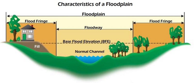
The floodplain is land that has been or may be covered by floodwater during the regional flood. The floodplain includes the floodway and floodfringe areas. These areas are labeled on the Flood Insurance Rate Maps as A, AE, A1-30, AO or AH zones.
The floodway is the channel of a river or stream and those portions of the floodplain adjoining the channel required to carry the regional flood discharge. The floodway is the most dangerous part of the floodplain -- it is associated with moving water.
The floodfringe is the portion of the floodplain outside of the floodway that is covered by flood water during the regional flood. The term floodfringe is generally associated with standing water rather than flowing water. Development is allowed in the floodfringe subject to local floodplain ordinance requirements.
The regional flood is the same as the 100-year flood, the 1-percent chance flood, or the base flood (FEMA).
The regional flood elevation is the elevation determined to be representative of large floods known to have occurred in Wisconsin or which may be expected to occur on a particular lake, river, or stream at a frequency of 1% during any given year. (Wisconsin only)
The base flood elevation is the elevation determined by FEMA to which flood water is expected to rise during the base flood.
The flood protection elevation is an elevation that is two feet above the regional flood elevation. (Wisconsin only)
More floodplain management acronyms and definitions.
Disasters
Flooding is Wisconsin's most costly disaster. When a community is flooded, the residents suffer both direct and indirect costs. The direct costs of flooding include:
- rescue and relief efforts;
- emergency preparedness;
- clean-up operations;
- rebuilding public utilities and facilities;
- rebuilding uninsured homes and businesses; and
- temporary housing costs for flood victims.
The indirect costs of flooding include:
- business interruptions and their loss of wages, sales and production;
- construction, operation and maintenance of flood control works;
- costs of loans for reconstructing damaged facilities;
- tax base declines in flood blight areas; and
- subsidies for flood insurance.
Wisconsin has suffered a significant flood at least once in every decade since 1880. Since 1990, the state has had 13 Presidential Disaster Declarations for flood-related events. After a Presidential Disaster Declaration is issued, FEMA releases disaster assistance funds, such as Hazard Mitigation Grant Program funds, to assist in reducing or eliminating flood risks in communities.
Wisconsin Emergency Management (WEM) is responsible for responding to disasters in Wisconsin. WEM also administers all federal disaster response and hazard mitigation programs.
Standards
Wisconsin has required communities (counties, cities, villages) to regulate floodplains since 1968 under Chapter NR 116, Wisconsin Administrative Code. Floodplain regulations are used to reduce flood risk and maintain the natural values of undeveloped floodplains. Wisconsin chose to enact floodplain management standards which exceed the minimum standards of the National Flood Insurance Program in order to ensure that development in flood prone areas has a reduced risk to flooding. The floods of 2008 and 2010 exceeded the anticipated base flood. Development built to meet the higher Wisconsin standards had reduced levels of damage.
Federal Standards
The federal government has set standards for floodplain management as part of the requirements for participating in the National Flood Insurance Program (NFIP) since 1968. The requirements for the NFIP can be found in 44 Code of Federal Regulation 59-72.
Local ordinances
Local floodplain ordinances must meet the requirements in ch. NR 116 and 44 CFR 59-72 if the community participates in the NFIP. Many communities have the local ordinance posted on the community website. The first point of contact for questions about floodplain management should be your county, city or village zoning administrator or other responsible official.
Staff
The DNR Floodplain Management Section is composed of three groups.
- The NFIP group, which focuses on ordinance review and approval, technical advice for local officials and individuals on regulations, mapping, flood insurance, mitigation, public education and outreach through newsletters and other publications, training for local officials and policy development and coordination.
- The engineering group, which assists local officials and consultants with understanding the engineering and mapping requirements under ch. NR 116 and FEMA.
- The mapping group, which coordinates with FEMA and local communities on the production of flood maps and studies.
Floodplain management staff can be reached in Madison as well as regional offices.

